Purpose of Asset Management
The primary purpose of asset management is to manage infrastructure. It takes a strategic approach to transportation planning, one that looks at the entire road network rather than as individual projects in distinct jurisdictions.
The asset management system requires the collection of data. The data allows transportation officials to monitor the transportation system and plan how to optimize the preservation, improvement, and timely replacement of roads. Instead of simply accounting for existing infrastructure, asset management strives to ensure the proper use and performance of those assets, a process that involves the continuous assessment of condition and evaluation of trade-offs between different actions.
Over the last ten years, the staff of Region 2 Planning Commission has assisted the Michigan Department of Transportation in the collection of asset management data. All of the region’s counties and several local units of government (e.g. Adrian, Tecumseh, Jackson, Hillsdale, and Blissfield) are using specialized software to rate the local roads.
MDOT’s goal is to gain accurate road ratings. To this end, they express the preference for the retention of the same raters from year-to-year, if possible. MDOT also sponsors annual PASER training workshops which are put on in conjunction with Michigan Technological University.
Asset Management Survey Data Collection
Data collection is currently limited to federal aid eligible roads (rating of local roads can be done at the option of local transportation agencies). Federal aid eligible roads are defined as any public road or bridge that is eligible for federal aid to be spent for the construction, repair, or maintenance of the particular facility. As of 2019, there are 1,642 miles of federal aid roads that are eligible for rating in the three-county region. The mileage per county breaks down as follows:
Hillsdale County – 422 Miles
Jackson County – 687 Miles
Lenawee County – 533 Miles
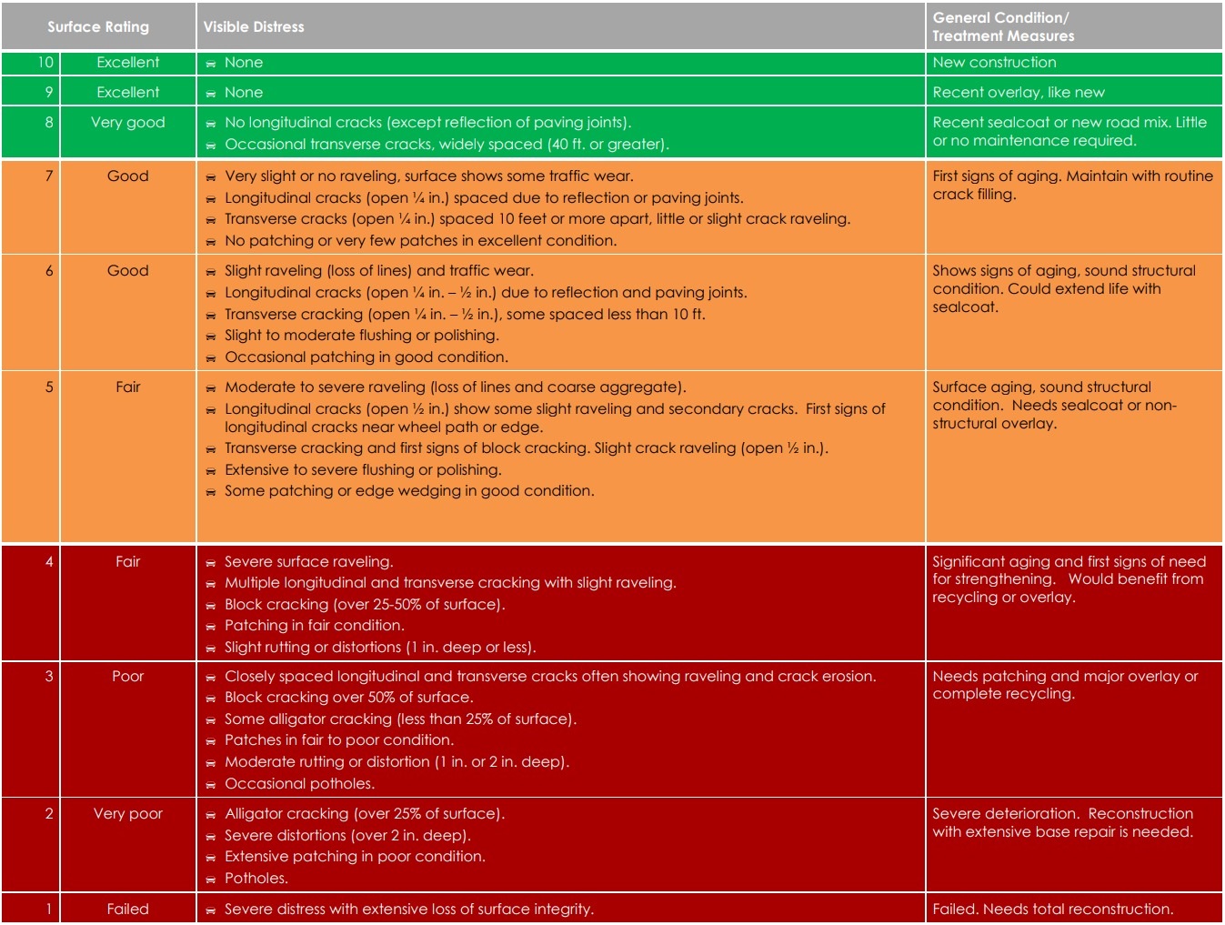
Data collection teams in each county consisted of representatives from MDOT, county road commission and/or city engineering departments, and Region 2 Planning Commission staff. Three types of data are collected on each road segment – number of lanes, surface sub-type, and surface rating. The data are collected using GPS system hooked to a laptop computer. The data is exported into Roadsoft software for analysis. Surface condition is rated according to this scale:
Federal aid roads in the Region 2 Planning area have been rated according to surface condition since 2006. Beginning in 2008, the Asset Management Council requested that regions rate only one-half of the federal-aid roads in their respective areas per year. Therefore since 2008, asset management data are based on a two-year cycle. Information available on the website begins in 2007. If you are interested in the 2006 data, please contact the Region 2 Planning Commission office.

