Population and some housing totals for 2010 were released by the US Census Bureau and the Michigan Center for Geographic Information in late March 2011. This webpage summarizes the available population information. Various maps and tables which further disseminate that information are also attached to the webpage.
The Region 2 Population in 2010
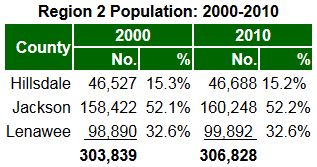
The population of the three-county area increased by 1.0% between the 2000 and 2010 to 306,828 people, despite a statewide loss of 0.6% of Michigan’s population during the same time period. The distribution of the regional population by county remains stable. Over half of the region’s population continued to live in Jackson County, just under a third continued to live in Lenawee County, and under a sixth continued to live in Hillsdale County.

Regional population growth occurred primarily in the townships given that the percentage of people living in a city or village decreased from just over a third (33.4%) in 2000 to under a third (31.8%) in 2010, a reduction of 3.9%. However, dispite the long-term trend towards fewer city and village residents, the City of Hillsdale (0.9%) in Hillsdale County; the Villages of Brooklyn (2.6%), Grass Lake (8.4%), Hanover (4.0%), and Springport (13.6%) in Jackson County, and the Villages of Blissfield (3.6%), Clayton (5.5%), and Clinton (1.9%) in Lenawee County gained residents during the first decade of the 21st Century. The highest growth townships were Somerset Township (8.1%) in Hillsdale County; the Townships of Grass Lake (28.7%), Sandstone (9.3%), and Spring Arbor (9.1%) in Jackson County; and the Townships of Franklin (8.0%), Rasin (16.2%), and Ridgeway (8.5%) in Lenawee County.
Listing of Attached Maps and Tables
Other Sources of Census and Demographic Information
The following links provide further access to a wide variety of demographic information:
A website hosted by the US Census Bureau which allows visitors to access community-based census information.
A website hosted by MHAL (the Michigan Department of History, Arts, and Librairies) which allows access to other demographic information.
A website hosted by the MEDC (Michigan Economic Development Corporation) which allows visitors to access to county-level information important to economic development.
The following local economic development organizations are also important sources of information:
Federal Congressional and State Legislative Districts
Click on the links below to view maps of the Federal Congressional and State Legislative Districts representing the residents of Region 2 and the local units of government it serves:
